


GD-5 Ultra Magnetotelluric System

• Wideband Detection (DC–10 kHz): Delivers full-spectrum coverage for shallow and deep subsurface structures.
• High-Precision 32-bit ADC: Achieves crystal-clear signal fidelity with ultra-low noise and distortion.
• Multi-Mode Integration: Seamlessly supports MT, AMT, and CSAMT modes for flexible exploration needs.
• Real-Time Geological Imaging: View resistivity profiles, phase curves, and apparent resistivity instantly on-site.
• Rugged, Field-Ready Design: IP67-rated enclosure withstands harsh weather, dust, and impact.
• Ultra-Low Power Consumption (< 5 W): Ideal for extended field campaigns with minimal energy use.
• Precise Timing Synchronization (≤ 30 ns): Dual GPS and thermostatic crystal clock ensure timing integrity in all conditions.
• High Data Capacity & Fast Transfer: Built-in 64 GB storage with USB, WiFi, and Ethernet connectivity.
The GD-5 Ultra Magnetotelluric System is built for deep geological, mineral, geothermal, and groundwater surveys, this powerful system integrates MT, AMT, and CSAMT methods in a single compact platform.
Built on advanced digital architecture, the GD-5 Ultra features six synchronized channels (three electric and three magnetic) for simultaneous broadband data acquisition.
Its wide frequency range (DC–10 kHz) and 32-bit high-speed sampling ensure exceptional resolution from shallow to ultra-deep layers of the Earth’s crust.
With real-time imaging, ultra-low noise design, and GPS-based nanosecond synchronization, every measurement captured is precise and ready for immediate interpretation even in the most remote field environments.
Applications
• Mineral and Metal Exploration – Detect conductive ore bodies, faults, and mineralized zones.
• Geothermal Resource Assessment – Identify reservoirs, caprock, and hydrothermal structures.
• Groundwater Detection – Map aquifers, salinity boundaries, and recharge zones.
• Oil & Gas Exploration – Characterize deep structures and fluid migration pathways.
• Engineering & Tunnel Surveys – Assess geological stability before excavation.
• Scientific Research – Study crustal conductivity, fault zones, and tectonic structures.
Related Products
• Multi-Channel Operation:
Supports simultaneous data acquisition from multiple electrodes, significantly improving survey speed and data accuracy.
• High Power Output:
Delivers strong current injection for deep detection and high-resistivity formations, ensuring reliable data even under challenging ground conditions.
• Intelligent Control System:
Features a microprocessor-based architecture with automatic ranging, polarity switching, and real-time monitoring for safe and efficient operation.
• High Precision Measurement:
Advanced digital filtering and noise reduction technology ensure stable, interference-free signals for accurate subsurface mapping.
• Flexible Configuration:
Compatible with multiple electrode arrays (Wenner, Schlumberger, Dipole-Dipole, etc.) for resistivity and induced polarization (IP) surveys.
• Durable Field Design:
Built with robust casing and weather-resistant components, making it ideal for both field and laboratory use.
Technical Sheet
1. Imaging Chip: 1/3” color CCD, sensitivity 0.1Lux.
2. Display: LCD, 12 inches, resolution 1024*768.
3. Lens: Manually fine-tune the focus; the lens is 360 degrees horizontally, tilted 180 degrees to rotate, freely controlled and can stay in any position.
4. Illumination Unit: front LED patch lamp beads, the brightness of the light source is adjustable in 8 levels.
Measurement Depth: 300M, 400M, 500M, 600M, 800M, 1000M
5. Storage Unit: U Disk.
6. Probe: Panorama/ rotation can be replaced at will, 40-120mm.
7. Working Voltage: AC 220V50Hz.
8. The tensile strength of the cable is 250kg.
9. The maximum pressure of the probe is not less than 15Mpa.
Controller Unit
Screen 12inch
Storage 32GB (SD card)
Keyboard Yes
Rotary 360 Degree rotary
Focus Adjustable
Winch Unit
Electric AC 220V
Cable core 6-core
Wheel type 0-500m
Skid type 501-1000m
Probe
Diameter 75mm
Rotary Yes
Focus Yes
Light Adjustable (+1 and -1)
Centralizer Yes
View angle Down and Side
• High Measurement Accuracy: It delivers reliable resistivity readings with excellent anti-interference performance, even in complex geological conditions.
• Automatic Data Processing: It is integrated with intelligent system for real-time data analysis, curve plotting, and geological profiling without the need for external computers.
• User-Friendly Operation: It has one-touch control and clear LCD interface simplify field operations, reducing survey time and improving productivity.
• Powerful Performance: It is capable of high-voltage and long-distance measurements, enabling deep exploration up to several hundred meters.
• Durable & Portable Design: Rugged construction and compact build for easy transport and dependable use in diverse environments.
High-Power Transmission & Fast Shutdown
WTEM’s robust transmitter delivers large power output and a rapid shutdown mechanism that extends detection range and improves resolution, especially in shallow surveys.
Superior Anti-Interference Capability
Built to withstand electrical noise such as atmospheric interference and 50/60 Hz industrial signals, the WTEM system ensures high-quality data in even the most challenging environments.
Versatile Configuration
The WTEM receiver pairs with either high-power transmitters for deep exploration or smaller transmitters for shallow investigations, giving you flexible deployment across project types.
Advanced Synchronization
Support for multiple synchronization modes — including cable and GPS synchronization — ensures precise timing and stable data acquisition across survey sites.
Lightweight & Efficient
Designed with portability and low power consumption in mind, the WTEM system performs reliably in the field while minimizing logistical complexity.
User-Friendly Interface
An intuitive control interface simplifies setup and data collection, while integrated software tools support real-time monitoring and post-survey analysis.
Depth: 100m/150m/300m/500m
Measuring time: 8-10min
Measurement data unit electric field component of different frequencies of the earth electromagnetic field ΔVs (mV)
Maximum Channels: 18 channels
Display Screen: Industrial 10.1-inch HD touch screen.
A/D conversion: 16-bits 1Msps
Minimum resolution: 0.001mv
Point selection: 1-18 points optional.
Power consumption: about 9W
Working environment temperature: -20°C ~ +50°C
Controller: 32-bit high speed CPU
Standby time: 8h
Cable: 2.5m point pitch, 10m line pitch 54.7m in total length
Electrode: Each comes standard with 22pcs
Host Weight: 1.95kg
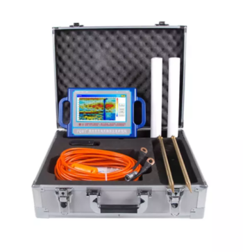
Depth 100 / 150 / 300 / 500 Meters
Frequency Single, Triple, 36/40/56frequency
Channel 8
System PQWT
LCD Industrial 7-inch HD touch screen
Units of Measurement △Vs(mV)
Measurement Range 0mV-2000mV
Stand-by Time 8-10 hours
Power Supply Battery Model #26650; 3.7V 4000mAh Rechargeable lithium battery
Multilingual support
Depth: 300 Meters
Frequency: Single, Triple, 40 Frequency
Channel: 6 Channels
Display: Industrial 7-Inch HD Touch screen
Measurement Range: 0mV – 1500Mv
Stand-by Time: 8-10 hours Power Supply: Battery Model #26650; 3.7V
4000mAh Rechargeable lithium battery