


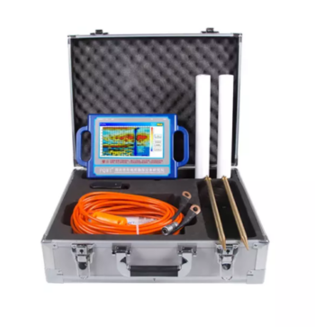
PQWT-GT500A

Depth: 100m/150m/300m/500m
Measuring time: 8-10min
Measurement data unit electric field component of different frequencies of the earth electromagnetic field ΔVs (mV)
Maximum Channels: 18 channels
Display Screen: Industrial 10.1-inch HD touch screen.
A/D conversion: 16-bits 1Msps
Minimum resolution: 0.001mv
Point selection: 1-18 points optional.
Power consumption: about 9W
Working environment temperature: -20°C ~ +50°C
Controller: 32-bit high speed CPU
Standby time: 8h
Cable: 2.5m point pitch, 10m line pitch 54.7m in total length
Electrode: Each comes standard with 22pcs
Host Weight: 1.95kg
The PQWT-GT Auto-Analysis Geophysical Detector is an advanced 8th-generation multi-channel groundwater and geological exploration instrument developed by Hunan Puqi Geologic Exploration Equipment Institute.
Using the natural electric field frequency selection method, it enables precise detection of underground water, mineral veins, geological structures, tunnels, cavities, and landslides.
it is equipped with five patented technologies for automatic analysis, mapping, and real-time 3D visualization, delivering accurate, efficient data collection and interpretation.
It supports multi-channel, multi-frequency measurement, eliminating time-difference errors and stores over 999 survey results, making it ideal for geophysical surveys, hydrogeological studies, and environmental engineering application
Related Products
Multilingual support
Depth: 300 Meters
Frequency: Single, Triple, 40 Frequency
Channel: 6 Channels
Display: Industrial 7-Inch HD Touch screen
Measurement Range: 0mV – 1500Mv
Stand-by Time: 8-10 hours Power Supply: Battery Model #26650; 3.7V
4000mAh Rechargeable lithium battery
Depth 100 / 150 / 300 Meters
Frequency Single, Triple, 36/40/56frequency
Channel 8
System PQWT
LCD Industrial 7-inch HD touch screen
Units of Measurement △Vs(mV)
Measurement Range 0mV-2000mV
Stand-by Time 8-10 hours
Power Supply Battery Model #26650; 3.7V 4000mAh Rechargeable lithium battery
• Wideband Detection (DC–10 kHz): Delivers full-spectrum coverage for shallow and deep subsurface structures.
• High-Precision 32-bit ADC: Achieves crystal-clear signal fidelity with ultra-low noise and distortion.
• Multi-Mode Integration: Seamlessly supports MT, AMT, and CSAMT modes for flexible exploration needs.
• Real-Time Geological Imaging: View resistivity profiles, phase curves, and apparent resistivity instantly on-site.
• Rugged, Field-Ready Design: IP67-rated enclosure withstands harsh weather, dust, and impact.
• Ultra-Low Power Consumption (< 5 W): Ideal for extended field campaigns with minimal energy use.
• Precise Timing Synchronization (≤ 30 ns): Dual GPS and thermostatic crystal clock ensure timing integrity in all conditions.
• High Data Capacity & Fast Transfer: Built-in 64 GB storage with USB, WiFi, and Ethernet connectivity.
High-Power Transmission & Fast Shutdown
WTEM’s robust transmitter delivers large power output and a rapid shutdown mechanism that extends detection range and improves resolution, especially in shallow surveys.
Superior Anti-Interference Capability
Built to withstand electrical noise such as atmospheric interference and 50/60 Hz industrial signals, the WTEM system ensures high-quality data in even the most challenging environments.
Versatile Configuration
The WTEM receiver pairs with either high-power transmitters for deep exploration or smaller transmitters for shallow investigations, giving you flexible deployment across project types.
Advanced Synchronization
Support for multiple synchronization modes — including cable and GPS synchronization — ensures precise timing and stable data acquisition across survey sites.
Lightweight & Efficient
Designed with portability and low power consumption in mind, the WTEM system performs reliably in the field while minimizing logistical complexity.
User-Friendly Interface
An intuitive control interface simplifies setup and data collection, while integrated software tools support real-time monitoring and post-survey analysis.
• 8-channel simultaneous measurement for rapid data acquisition
• Wi-Fi enabled for seamless remote control and data transfer
• Expandable electrode capacity – supports up to 112 electrodes with 5m spacing
• Marine and land survey compatibility, ideal for complex terrains and aquatic environments
• Integrated GPS and EarthImager™ software for precise positioning and advanced inversion modeling
• Rugged field-ready design with heavy-duty transport case, stainless steel electrodes, and robust cabling
• High Sensitivity & Precision: Integrated digital sensors ensure accurate seismic signal detection.
• Wireless & Efficient: Cable-free design simplifies deployment and reduces operational costs.
• Durable Construction: IP-rated protection for use in rugged field conditions.
• Long Battery Life: Low power consumption for extended continuous recording.
• Flexible Applications: Ideal for 2D/3D seismic surveys, structural monitoring, and academic research.
• User-Friendly Software: Intuitive interface for setup, synchronization, and data retrieval.
Depth 100 / 150 / 300 / 500 Meters
Frequency Single, Triple, 36/40/56frequency
Channel 8
System PQWT
LCD Industrial 7-inch HD touch screen
Units of Measurement △Vs(mV)
Measurement Range 0mV-2000mV
Stand-by Time 8-10 hours
Power Supply Battery Model #26650; 3.7V 4000mAh Rechargeable lithium battery