

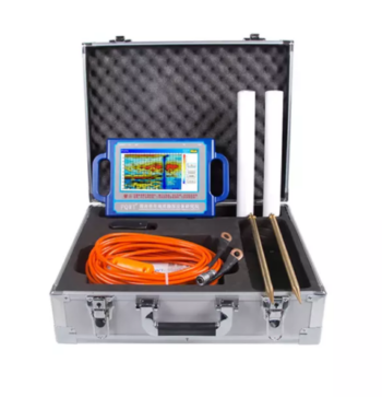
PQWT-TC300


Multilingual support
Depth: 300 Meters
Frequency: Single, Triple, 40 Frequency
Channel: 6 Channels
Display: Industrial 7-Inch HD Touch screen
Measurement Range: 0mV – 1500Mv
Stand-by Time: 8-10 hours Power Supply: Battery Model #26650; 3.7V
4000mAh Rechargeable lithium battery
The PQWT-TC300 Automatic Mapping Water Detector is a high precision groundwater exploration instrument that uses the Earth’s natural electromagnetic field to analyze underground geological structures.
It automatically maps geological profiles in real time with one-click operation, eliminating complex computer processing. It is ideal for detecting aquifers, fractures and faults.
It performs efficiently across plains, hills, mountains, and basins. It is suitable for loating well positions and aquifer depths, boasting over 90% accuracy.
Related Products
• High Sensitivity & Precision: Integrated digital sensors ensure accurate seismic signal detection.
• Wireless & Efficient: Cable-free design simplifies deployment and reduces operational costs.
• Durable Construction: IP-rated protection for use in rugged field conditions.
• Long Battery Life: Low power consumption for extended continuous recording.
• Flexible Applications: Ideal for 2D/3D seismic surveys, structural monitoring, and academic research.
• User-Friendly Software: Intuitive interface for setup, synchronization, and data retrieval.
Depth 100m/150m/300m
Measuring time 6-8min
Measurement data unit electric field component of different frequencies of the earth electromagnetic field ΔVs (mV)
Maximum Channels: 18
Display screen unit: 10.1-inch HD touch screen (1024 *600)
A/D conversion: 16-bits 1Msps
Minimum resolution: 0.001mv
Point selection: 1-18 points optional
Power consumption: about 9W
Working environment temperature: -20°C ~ +50°C
Controller : 32-bit high speed CPU
Standby time: 8h
Cable: 2.5m point pitch, 10m line pitch 54.7m in total length
Electrode: Each comes standard with 22pcs
Host Weight: 1.95kg
• 8-channel simultaneous measurement for rapid data acquisition
• Wi-Fi enabled for seamless remote control and data transfer
• Expandable electrode capacity – supports up to 112 electrodes with 5m spacing
• Marine and land survey compatibility, ideal for complex terrains and aquatic environments
• Integrated GPS and EarthImager™ software for precise positioning and advanced inversion modeling
• Rugged field-ready design with heavy-duty transport case, stainless steel electrodes, and robust cabling
Depth 100 / 150 / 300 / 500 Meters
Frequency Single, Triple, 36/40/56frequency
Channel 8
System PQWT
LCD Industrial 7-inch HD touch screen
Units of Measurement △Vs(mV)
Measurement Range 0mV-2000mV
Stand-by Time 8-10 hours
Power Supply Battery Model #26650; 3.7V 4000mAh Rechargeable lithium battery
Depth: 400 Meters
Frequency: Single, Triple, 48frequency
Measurement data unit: electric field component of different frequencies of the earth electromagnetic field ΔVs (mV)
Channel: 8
System: PQWT
LCD: Industrial 7-inch HD touch screen
Units of Measurement: △Vs(mV)
Measurement Range: 0mV-1000mV
Display: LED indicator
A/D conversion: 8-bit 1Msps
Input impedance: ≥10MΩ
Relative humidity: ≤85%
Power consumption: about 1W
Working environment temperature: -20°C ~ +50°C
Power Supply: Battery Model #18650; 3000mAh Rechargeable lithium battery
Accurate Depth Measurement: Provides quick and precise readings of water depth with a standard resolution of 0.5 mm.
Audible Signal: Emits a clear tone when the probe contacts water, making detection easy even in noisy environments.
Durable Tape: Uses a flat, high-tensile, non-stretch tape with clear depth markings for long-term reliability.
Battery Operated: Lightweight and portable, ideal for field use without the need for external power.
Multiple Length Options: Available in lengths ranging from 100 meters to 1000 meters, suitable for shallow and deep wells