



Related Products
Technical Sheet
1. Imaging Chip: 1/3” color CCD, sensitivity 0.1Lux.
2. Display: LCD, 12 inches, resolution 1024*768.
3. Lens: Manually fine-tune the focus; the lens is 360 degrees horizontally, tilted 180 degrees to rotate, freely controlled and can stay in any position.
4. Illumination Unit: front LED patch lamp beads, the brightness of the light source is adjustable in 8 levels.
Measurement Depth: 300M, 400M, 500M, 600M, 800M, 1000M
5. Storage Unit: U Disk.
6. Probe: Panorama/ rotation can be replaced at will, 40-120mm.
7. Working Voltage: AC 220V50Hz.
8. The tensile strength of the cable is 250kg.
9. The maximum pressure of the probe is not less than 15Mpa.
Controller Unit
Screen 12inch
Storage 32GB (SD card)
Keyboard Yes
Rotary 360 Degree rotary
Focus Adjustable
Winch Unit
Electric AC 220V
Cable core 6-core
Wheel type 0-500m
Skid type 501-1000m
Probe
Diameter 75mm
Rotary Yes
Focus Yes
Light Adjustable (+1 and -1)
Centralizer Yes
View angle Down and Side
Depth: 400 Meters
Frequency: Single, Triple, 48frequency
Measurement data unit: electric field component of different frequencies of the earth electromagnetic field ΔVs (mV)
Channel: 8
System: PQWT
LCD: Industrial 7-inch HD touch screen
Units of Measurement: △Vs(mV)
Measurement Range: 0mV-1000mV
Display: LED indicator
A/D conversion: 8-bit 1Msps
Input impedance: ≥10MΩ
Relative humidity: ≤85%
Power consumption: about 1W
Working environment temperature: -20°C ~ +50°C
Power Supply: Battery Model #18650; 3000mAh Rechargeable lithium battery
• Multi-Channel Operation:
Supports simultaneous data acquisition from multiple electrodes, significantly improving survey speed and data accuracy.
• High Power Output:
Delivers strong current injection for deep detection and high-resistivity formations, ensuring reliable data even under challenging ground conditions.
• Intelligent Control System:
Features a microprocessor-based architecture with automatic ranging, polarity switching, and real-time monitoring for safe and efficient operation.
• High Precision Measurement:
Advanced digital filtering and noise reduction technology ensure stable, interference-free signals for accurate subsurface mapping.
• Flexible Configuration:
Compatible with multiple electrode arrays (Wenner, Schlumberger, Dipole-Dipole, etc.) for resistivity and induced polarization (IP) surveys.
• Durable Field Design:
Built with robust casing and weather-resistant components, making it ideal for both field and laboratory use.
• Dual Functionality: Measures both resistivity and induced polarization (IP) with exceptional precision.
• High Power & Depth: Advanced signal processing allows deep penetration and stable readings even in complex terrains.
• Intelligent Design: Automatic data recording, self-calibration, and real-time display simplify field operations.
• User-Friendly Interface: Intuitive touchscreen display and simple menu navigation enhance operational efficiency.
• Reliable Performance: Excellent anti-interference capability ensures accurate measurements in various geological environments.
• Flexible Data Management: Supports USB data export and PC software for data processing, mapping, and reporting.
• High Sensitivity & Precision: Integrated digital sensors ensure accurate seismic signal detection.
• Wireless & Efficient: Cable-free design simplifies deployment and reduces operational costs.
• Durable Construction: IP-rated protection for use in rugged field conditions.
• Long Battery Life: Low power consumption for extended continuous recording.
• Flexible Applications: Ideal for 2D/3D seismic surveys, structural monitoring, and academic research.
• User-Friendly Software: Intuitive interface for setup, synchronization, and data retrieval.
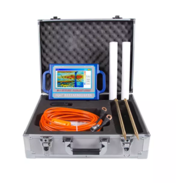
Depth 100 / 150 / 300 / 500 Meters
Frequency Single, Triple, 36/40/56frequency
Channel 8
System PQWT
LCD Industrial 7-inch HD touch screen
Units of Measurement △Vs(mV)
Measurement Range 0mV-2000mV
Stand-by Time 8-10 hours
Power Supply Battery Model #26650; 3.7V 4000mAh Rechargeable lithium battery
• 8-channel simultaneous measurement for rapid data acquisition
• Wi-Fi enabled for seamless remote control and data transfer
• Expandable electrode capacity – supports up to 112 electrodes with 5m spacing
• Marine and land survey compatibility, ideal for complex terrains and aquatic environments
• Integrated GPS and EarthImager™ software for precise positioning and advanced inversion modeling
• Rugged field-ready design with heavy-duty transport case, stainless steel electrodes, and robust cabling